


New App Tracks Polar Ice Thickness Using ESA Satellite Data
A new iPhone and iPad app can track the polar ice sheets and sea ice thickness in Greenland and Antarctica using data from a European Space Agency satellite.
The agency said Wednesday users can find information about the CryoSat satellite’s mission including images, videos, archived news and an overview of how it obtains and delivers data.
ESA says information on CryoSat’s current position is automatically updated, including its visibility over selected ground stations.
The app also offers a 3D model that allows users to zoom in on how the satellite – launched in November 2009 - is built and discover its instruments, such as the radar altimeter for measuring ice thickness.
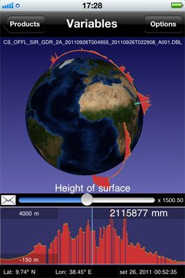
According to ESA, the data feature is what makes the app unique as it gives access to all of CryoSat’s measurements and helps users visualize the ice sheets by providing a vertical profile over the area.
Published by Medicaldaily.com


