


Satellite Tracks Vineyard Water Levels, Aids Farming Management
The European Space Agency on Tuesday highlighted how farmers are benefiting from a satellite service that allows them to determine how much a vineyard should be watered and when.
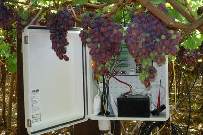
Scientific advisory firm WaterWatch, which aids water management practice through its Grapelook service, monitors how much water is released from the plants, how efficiently the water is being used, and how much biomass is grown, using satellite remote sensing.
Using technology that combines Earth observation data and field measurements, moisture readings are sent to a processing center through a satellite link.
The grape growers and water managers can access the information, once it’s processed, through a publicly available Google Maps based website, which can be found at www.GrapeLook.co.za.
The grape growers will also receive information on irrigation scheduling and fertilizer applications facilitating management decisions via SMS/MMS.
Tested in South Africa with selected grape growers this year, the service proved successful and the group received forecasts on soil moisture and irrigation requirements for their farms as well.
“The trial period of this project showed that the farmers and water authorities were supportive of such a service,” explains Olivier Becu, an ESA technical officer.
ESA said that the system can increase the amount of grapes being harvested while raising the quality of the wine and using less water.
“The GrapeLook service shows how satellite technology benefits farmers,” said Annemarie Klaasse, land and water use specialist at WaterWatch.
“It not only helps farmers to reduce water usage, it also increases sustainability and production. Next steps are to expand the service to other crops and areas.”
Published by Medicaldaily.com


